Jerbourg Signal Station and the Saumarez Tower
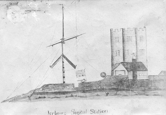
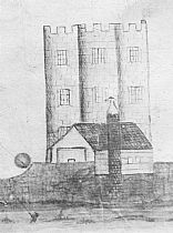
The story of a picture in our collection, rather than a book; a black-and-white photograph of a watercolour showing Jerbourg Signal Station. Behind the signal-post is Saumarez Tower, the only known representation of this short-lived landmark. A copy of this watercolour is in the possession of the Guernsey Museum. In that picture, the roofs and the small cylindrical tower are shown as red. The photograph, taken at the behest of Captain Philip de Saumarez, was lent a century ago to local historian Edith Carey by Mrs Ozanne, the artist's descendant, and placed in one of Miss Carey's scrapbooks, now at the Library.
From The Star, Saturday January 12, 1901: Jerbourg Signal Station
'Where Doyle’s Pillar now stands was then a Tower called Saumarez Tower, spoken of by Alexander Deschamps in his Sailing Directions,¹1818. Since this appeared (in an article of January 1901) we have been very kindly given some information concerning that Tower, besides having been lent a watercolour painting made of the Tower before it was pulled down about the year 1816. It is called the Jerbourg Signal Station.
Judging from the painting before us it was circular in shape, three storeys in height—each storey apparently representing a height of 10 feet—with embrasures all round the upper platform from whence a very fine view must have been obtainable. The tower appears to be very solidly built in dressed stone. Adjoining this is the keeper’s cottage, to which a tall round red brick chimney is attached. A few yards away is a lofty signal post, half-way up of which is a yard-arm; some feet below the two arms of a semaphore are attached. From the stays of the post a Union Jack is hoisted. The whole is depicted as surrounded by a stone wall, over which the signal man is shown with a telescope applied to his eye, no doubt on the lookout for vessels. It appears that the Doyle’s Pillar was not actually built on the site of the tower which was pulled down at the time the pillar was erected, as the basement stones of the tower are yet to be seen in a circle some 50 yards or so from the well-known landmark called Doyle’s Monument which was erected in the early part of last century. It may be interesting to know that the late Captain Philip de Saumarez obtained the painting mentioned above from the family of the late Mr. William White, for many years in business in Fountain-street, and had several photographs taken of it. The painting is now in the possession of Mrs S D Ozanne, of Mill-street, one of the daughters of the late Mr. William White, whose father, Captain William P. White, RN, was appointed keeper of the Tower about 1812, being incapacitated from active service in the British Navy through wounds received in action against the French. Captain William Pitts White, who held his appointment until the Tower was pulled down, was born at Weymouth in 1765, died in Guernsey in the year 1846, and is buried in the New Cemetery.' [See Rep. & Trans. Soc. Guern. 1901, p.54.]
The Jerbourg Tower is only known from this picture, which was lent to local historian Edith Carey by Miss Ozanne around a century ago, and a representation of it on Peter de Havilland’s map of Guernsey’s fortifications of 1802. In 1778 the construction of fifteen new-style watchtowers,² or maisons de guet, was begun around Guernsey’s coast, at the behest and design—though much to the mortification of the Guernsey taxpayer, mostly not at the expense—of the British authorities. These towers, most of which still exist, are famous Guernsey landmarks and are known by the numbers (1-15) assigned to them when they were built, as well as location. Jerbourg Tower was not one of these; in de Havilland’s map towers are shown in silhouette; this one is taller than the others (having had three storeys rather than two), with the crenellations that can be seen in the watercolour, and flying a signal flag from the top.
The de Sausmarez family were made châtelains for the fort in 1331. This meant that they had responsibility for its upkeep and defence. Jerbourg was regarded as an alternative to Castle Cornet, should that fall into enemy hands; this did in fact occur in 1338, around which time the King paid for its 'costly' (somptueux) rebuilding. Until Napoleonic times it was the second most important fortification in Guernsey, and whenever the French threatened the islands it would be repaired; but at the end of the 18th century attention turned instead to the North of the island, whence it was feared an invasion would come. Jerbourg, although provided with batteries and a barracks, became more of a viewing point, from which information about ship movements could easily be transmitted to Castle Cornet and then later to Fort George, and a place to garrison soldiers just far enough away from those places to provide reinforcements.
The 'Château' of Jerbourg was more like an Iron-Age hill-fort than a castle proper, enclosed by a defensive wall built in 1328. In the Middle Ages it had a keep of sorts, a square tower used for storage of wheat and presumably other sundries, and this may be the building marked on a map of Henry VIII’s time in the British Library. Despite the land belonging to the de Sausmarez family, however, it seems that parcels within the Château were allocated or claimed by individuals, who became responsible for that piece of it. In 1342 Edward III asked Thomas de Hampton 'in order to ensure the safety of our loyal subjects ... we order you to assign to each and everyone, from the richest to the poorest, areas within the said castle, depending on the rank of person and the amount of personal goods each has, and to expect them to defend and provision their own areas whenever war seems likely.' In 1381 Edward III instituted a Royal Commission on the ownership of Jerbourg; Matthew de Saumarez was allowed to keep it under certain conditions, which were those detailed in a writ from Edward II in 1330. In 1350, however, the king seems to have given up on it and ordered St Peter Port to be fortified instead.4 In 1629, under yet another threat from France, it was agreed by the States that it was to be repaired at the expense of the islanders; perhaps as an afterthought to mollify disgruntled taxpayers, Thomas Andros, to whom the de Sausmarez titles had passed (they would be bought back later), had to agree that anyone could build within its walls in order to protect themselves and their family, provided his rights were not infringed. This perhaps led to some difficulty for a later châtelain, Matthew de Sausmarez.
The Jerbourg peninsula was not chosen as the site of one of the fifteen new watchtowers; these remained unfinished when, in 1780, Matthew de Sausmarez offered to repair the dilapidated watchtower at Jerbourg, at the taxpayers expense (he asked the States to pay him £25 sterling), provided that he could re-use materials already on site. The ground floor was to have an appartement for the soldiers to sleep in; a room on the first was to be 'for watch and guard duty.' Matthew5 included the proviso that while he and his heirs would guarantee that the building would remain in a fit state to fulfil its function, repairing it whenever necessary, the watchtower was eventually to pass into his family’s possession, for their use, once it was no longer needed. The proposition was accepted and he then constructed the Tour de Jerbourg, or Saumarez Tower, which was evidently also used for signalling, which might explain its height, and as a landmark. The watercolour depicts a building which was not round—perhaps hexagonal—with crenellations, whose windows had leaded glass and were neatly arranged in vertical and horizontal rows, quite unlike the other new squat and simple towers built for the British Government.
.JPG)
The ground floor contained two guardhouses. Its position can be clearly seen on the 'Duke of Richmond map' of 1787 (the first full survey of Guernsey, commissioned by the then Duke of Richmond: click on the image to enlarge it). The curve in the cliff path around the back of the tower is still evident today. By Gray’s map of 1816 the building had gone (see note 1) and was replaced by the first Doyle Pillar, about 150 metres away.
In 1803 de Sausmarez was trying to regain control of the tower by offering the States free use of his land at the Bec du Nez and building materials from it, and even a right of way over it, so they could erect a proposed Watchtower and Fort, in exchange for the Jerbourg Tower and the land it was built on. The States rejected his first proposition, but accepted a second in 1807, apparently suggested by the Hon. Brigadier-General Peter Heron, Commander-in-Chief of Guernsey, that they not only give up any right of the militia to keep watch from within the tower, but give him back the whole building and land 'in order to build a Signal Post to expedite as far as possible the communication of intelligence for the public good of this island,'6 and they asked Daniel de Lisle Brock to agree the price and pass contracts on their behalf. The site of the Tower is now a substantial German bunker, part of the Batterie Strassburg, and long-term base for cable and now telecommunications masts.
Captain White’s logbook as keeper of the Station begins in 1810, three years or so after the handover to de Sausmarez should have taken place, if it ever did. White describes the tower as 'unfurnished' when he arrived, and the soldiers at lodgings waiting for orders. It is unclear whether soldiers continued to lodge in the base of the tower, perhaps paying rent to Matthew de Sausmarez, but if they did it cannot have been a pleasant place to stay. On the 31st October 1810 'the window-shutters of the tower facing the sea torn off, iron work and all the glass of the windows blown to pieces by the violence of the gale. The principal crack of the tower more open, and the tiles on the pent-house [shed] going into the tower all blown off and broken;' and on November 10th, 'A heavy squall tore open the window shutters of the tower facing NW and broke the glass of the window to pieces and blew down part of the store room. The tower shook very much.' Saumarez Tower, cracked down the middle, did not last much over 30 years.
The Tower was replaced as landmark by the Doyle Pillar, a monument to General Doyle, first erected in 1816, following Doyle’s return to England.
¹ Deschamps, Alexandre, Sailing directions for Guernsey, Jersey, and all the British Islands in the Gulf of Avranches: with a full description of the tides, rocks, and appearances of the land from sea principally intended to guide strangers, 1818: Guernsey, Chevalier and Mauger. 'To those who have not been to Guernsey within these ten or twelve years, and who might have to call again to this Island, I give this caution; that about that period and for the forty years before, a Tower stood on the high S.E. point of Guernsey, called Jerbourg, and was called Saumarez's Tower. This was of great utility to distinguish the Island, but was taken down about twelve years ago, which might ocasion fatal mistakes. Conspicuous public or private buildings on the sea coasts, or even groups of trees, ought never to be removed without public notice.' (page 53). A literary portrait of the Captain in 1828 can be found in W. Proctor's 'Diary of a Voyage and a few sketches of Guernsey,' in Quarterly Review of the Guernsey Society, Spring 1981, pp. 12ff.
² Extensive information on the history of these towers, taken from original sources, can be found in Grimsley, E., Martello Towers: the Historical Development of the Martello Tower in the Channel Islands, 1998: Guernsey, Sarnian Publications.
³ Burns, R, ed., Excavations at Jerbourg, Guernsey: 1988, Guernsey, States of Guernsey (Museum Monograph No. 1), covers many aspects of the history of the peninsula from Stone Age to the building of the Batterie Strassburg in 1941.
4 '... pour la sauvegarde de nos fidèes sujets .. nous vous commandons de faire assigner à chacun d’iceux tant au plus grands qu’aux plus petits, certains départements dans le dit château ayant égard à la qualité des personnes et à la quantité de leurs biens, et de les obliger de le defender at de fournir les provisions chacun dans son department lorsqu’il y aura apparence de guerre.' From The Close Rolls of Edward III, 1342. See G.T. Derrick, Transactions of the Societe Guernesiaise IV (1903) 4, pp. 248 ff.; for the events of 1350: 'licence, in view of the fact that the castle of Chirburgh, in that island, wherein in time of war the people used to find refuge, is destroyed and cannot be repaired to the king's advantage, as he is informed, to enclose their town with a good and strong wall,' from De Saumarez, H. W., The Saumarez family in the Channel Islands, Société Guernesiaise 1935, pp. 281 ff. The original Latin is to be found in Havet, J., Les Cours royales de Iles Normandes, p. 233. For documents see Jerburgh Castle, notes in the Library collection, and pp. 23 ff. of Le Marchant deeds &c, vol. XXII, staff collection, concerning a house that the Le Marchant family kept within the castle at Jerbourg. Jerbourg was still in some ways operative as a fortification during the Civil War, as it was supposedly a target for a Royalist coup, along with Castle Cornet (see Marr, J, Royalist resistance &c, Toucan Press, 2003.).
5 At the same meeting of the States in January 1780, the States voted to accept the offer to buy a fort and land between Paris Street and Glategny from a group of local worthies ,who had raised £3000 tournois to buy it, and that the nominal payment of £50 they had asked should, as the donors stipulated, itself be used to defray expenses of building the fort (the fort, later Fort Amherst, was known at that time as Fort Subscription). The list of worthy donors includes many a substantial businessman and aristocrat, including two of the De Sausmarez family—but not Matthew. For details of the States rulings see Lee, George, E., Revd., Actes des Etats de l'Isle de Guernesey, Guernsey: Bichard & Cie., 1910, vols. II and III, and Maculloch, Robert, Recueil d'ordonnances de la cour royale de l'isle de Guernesey, rédigé sous l'autorité de la dite cour.
6 Actes des Etats, III, p. 215, 1807 'Qu'ils acceptent la proposition .... de lui céder la totalité da la dite Tour & terrein exempts de toute servitude que ce soit pour et au nom de Gouvernement de sa Majesté pour y etablir un Poste de Signaux afin d'accélérer d'autant plus promptement toute espèce d'intelligence pour le salut public de cette île ...'. A copy of a letter of August 23rd 1807 from Nicholas Vass at Portsmouth in the National Archives [ADM/227/365] reports that he has drawn a bill to Messrs John Chaseau and Robert Goodwin [a master carpenter] in final payment for the signal houses built at Les Vardes, Noirmont and the Tower of Jerbourg on Guernsey. He adds that Sir Edmund Nagle and Sir John Doyle propose signal stations at Fort Saumarez, Pleinmont, Mount Hermat, Prevôté, Icart, and Fort George to complete the chain.
Doug Ford, in Jersey Heritage Trust Magazine 2007, says that 'In France, a system of semaphore had been invented by Claude Chappe. It used two arms on a connecting cross arm which could be pivoted to pass messages over long distances. Chappe’s system offered a potential 196-combination code and proved to be the world’s first effective telecommunications system. Other countries copied it, with the first ones appearing in England in 1795. Peter Archer Mulgrave, described as ‘a commercial gentleman of ingenious mechanical ability,’ is credited with the introduction of the new system into Jersey in 1810, but there are no illustrations from the time showing this type of semaphore in the Island. Using semaphore, messages could be passed from Jersey to the other islands and could pass on information to similar stations in Guernsey, Sark and Alderney. The stations at Grosnez in Jersey, Jerbourg in Guernsey, Sark and Alderney had their telegraph arms made extra large to make them more identifiable across the sea.' For Mulgrave see Wilson, G., 'Signals across the Sea,' Review of the Guernsey Society, XLVIII (2), Summer 1991, pp. 34 ff., and the Low Head Museum in Tasmania.