Town Borders: Parishes and Barrieres de la Ville
St Peter Port Parish Magazine, July 1870. The Barrieres were redefined and extended for an important law of 1840 which modernised the Guernsey Law of Real Property. See Jeremie's commentary, On the Law of Real Property in Guernsey, Guernsey, Redstone, 1841.
Town boundaries
Barrières de la Ville
A Question of Parish Boundary (1891)
Medical services for the poor
Many persons in the Town are completely in the dark, as to what are the boundaries of the parishes of St Peter Port, St John, and Holy Trinity, and in which of these parishes they live.¹ This is very inconvenient, as they ought always to know who their own clergyman is, and it is especially necessary at the time of a baptism, a wedding, or a funeral.
St Peter Port lies in the middle between the two. On the north of the town, if you start from Glatney with your back to the sea, all is in St Peter Port, which you have on your left going up Truchot and the Vauxlorens. The wall between the property of Commissary-General Dobrée, and a line cut across Cambridge Park, going through the old Plough Yard to the Fosse Andry, next divides the two parishes. Then all on the left is in St Peter-Port continuing along Collings-road to the corner below Valnord, when you turn to the right, and all on the left to the borders of the parish of Ste-Marie du Castel remains in St Peter Port. At that point, near the Bessières, the parishes of St Peter Port, St John, Ste-Marie du Castel, the Vale, and St Andrew's all converge. To the west by a line running along the valley at the bottom of the Rohais and Foulon, and Vauquiédor, St Peter-Port skirts St Andrew's; then it reaches St Martin's. The line runs along the valley at the back of Mount Row to the Ville-au-Roi, more commonly known as 'The Traveller's Joy,'² and then descending the Ruettes Brayes, all on the left is in St Peter-Port, as far as the back of the Pierre Percée estate. There the line is drawn along the wall, which separates it from the adjoining property, to Brabant; ascending Prince Albert's road all is in St Peter-Port on the left, as far as the corner by Colborne Place, when going along Mount-row, both sides are in this parish, as also along King's-road, and on the left by Belmont-lane into Queen's-road. Then you turn down the lane along the property of T.S. Lacy, Esq., and take the first turn into Victoria-road, the whole of which is in St Peter-Port. You next turn to the right below the French Wesleyan Chapel, and go in front of Victoria Terrace, and return into Victoria-road by the turning next above the cabinet-maker's. From the bottom of Victoria-road you go on to Burnt Lane, and at its termination cross Mansell-street by the flight of steps into the Bordage - then you ascend Tower Hill Steps and descend Cliff-street by the Steps to the South Esplanade. In taking this walk all upon your left hand, and in the case of half of Mount-row, King's-road, and the bottom of Victoria-road, both left and right, is in St Peter-Port. It may not seem very easy to understand on paper, but is very clear in reality. The district of St Stephen's is not in any sense cut off from the parish of St Peter-Port, no more is the district of which the present Minister of St James has the supervision. All that lies to the right of the line mentioned on the north, as far as the parish of St Sampson, is in St John's parish, and all that lies on the right, on the south, as far as the parish of St Martin, is in Holy Trinity, except Fort George and the property of Government, which remains in the parish of St Peter-Port.
[Translation] The boundaries of this enclosure are delimited thus: everything to the left of this line up to the sea is to be included within the Barrières, viz—
Starting at the shoreline and passing in front of and via the crossroads at the warehouse known as Long Store, take the road leading to St. John's Church; follow the Amballes road as far as the path on the left that leads to the Côtils, and with the estate of John Elisha Tupper, esq., to the left and Castle Carey to the south, go down via the Vauxlaurens pump, as far as the north-western wall of the Town Hospital: follow the line of the wall up as far as the road known as the Rue de l'Hôpital; go up this road, and passing the front entrance to St James' Church, continue up as far as the crossroads at the top of St James' street. From there take the main Castel road as far as the Grange crossroads; turn left, and passing more or less in a straight line in front of the house of the heirs of William Pierre le Cocq, esq., climb the steep little road to the east of Mr Crick's, as far as the Petites Fontaines. Take a straight line from here as far as the pump in the main road, Mount Durand; now walk across in a straight line as far as the sluice at the Charotterie. From there go up the Park Lane Steps where you will meet the road coming from La Varde; then follow Havelet Street as far as the sea.
'[The French occupied Castle Cornet 1298-1345.] Accordingly about 1350 an order came from the King for surrounding the town with a strong wall. To this the Guernseymen were short-sighted enough to object on grounds of expense, and a second message was sent out insisting that the King's directions be carried out. No copy of the first order has been preserved, but here is a copy of the second, that of 1351, which recites the other. It is very interesting and is dressed to John Mautravers, the Governor, to this effect: 'We, having heard that our Castle of Jerbourg, which the people of Guernsey have been accustomed to use as a place of refuge in time of war, had been destroyed, had ordered that our Tower of St Peter Port, which is a place adapted for such a refuge, should be enclosed with a strong wall. And, in order to provide the necessary funds, we directed that a tax should be levied on all goods bought and sold in the Island, one half being paid by the buyer and the other half by the seller; the said tax to continue for one year, and its proceeds to be devoted to the building of the said wall. But there are certain rebels among them, who positively refuse to pay it, saying that they already pay us a tax called Aide du Roi, and are therefore free; but do they not see that this is for their personal safety (for which they are bound to provide), and is not for our advantage at all? Where fore now, we charge you upon your allegiance that, commencing on St Bartholomew's Day next, you collect that tax for once year, and that you intermediately lodge in prison any who shall in any way oppose the said collection.'
The scheme thus was to convert the Town into a citadel. The situations of the gates are still marked, and the names of the towers which guarded its north and south extremities are still borne by the spots on which they stood. The only gate upon the sea side was placed upon a spot to the east of the present south aisle of the Town Church, and the stone marking the spot may be seen against the wall of the old house which is the northernmost of the block occupied in part by the Church of England Temperance Society's Café. starting from this spot and following the line of the Town Wall southward along the seashore, we find that it turned inland near the present Castle Vaudin, from which it climbed the hill near Cliff Street, and then going northward was cut by another gate at the top of Cornet Street, Here, mounting guard over the gate, stood one of the flanking towers, from which the wall was built down the side of the hill to Fountain Street, which it crossed just above Rosemary Lane and here a third gate was placed. Going on from this northward, across the present market-place and the site of the Commercial Arcade, and along the back of High-Street, a fourth gate opened in to it at Smith-Street, the stone marking which is fixed in the wall between the door of the Post Office and Messrs Lovell and Cox. From this spot, cutting across the lower part of Forest Lane, it was continued to a fifth and last gate at the bottom of the Pollet, below the house formerly the residence of the late Bailiff, Sir Edgar MacCulloch [there was a sixth, see below]. On the sea-shore to the north of this stood the second of the two flanking towers, and from this gate the wall turned southward along the shore to the gate from which we started. Now these gates were the original Barrières of the Town. In 1840, when considerable changes were made in the Guernsey Law of Inheritance, the line of the Barrières was much extended, real property situated within this line descending in a different manner from that outside, as is well known.' [From Cox, C., 'St Peter Port in bygone times,' Report and Trans. of the Société Guernesiase, V (3) 1907, pp. 333 ff.]
Ordonnance de la Cour Royale, 6th October 1684.
As it has been reported by the Town Constables that the Barrières de la Ville are largely broken or missing, and that they need to be renewed, IT IS ORDERED THAT the said Constables and Douzeniers go to the original sites of the Barrières, investigate the exact positioning of the stones and erect new ones in their place. They are also to keep a register of the places and positions of the stones, for future reference. And the cost of this operation is to be funded by a tax levied on the parishioners. [From the French.]
From Receuil d'Ordonnances, Vol. I, ed. Robert MacCulloch, 1852.
The Barrières were replaced in 1700:
FOUNTAIN STREET IMPROVEMENTS
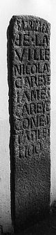
In carrying out these improvements, the stone marking the barrier of the Town Parish was unearthed, and being found in a good state of preservation, the letters upon it have been re-cut by Mr Le Page, the Contractor, and it has been placed in the wall of Mr Mahy's premises at the foot of the steps leading to Rosemary Lane. The following is the inscription: "Barrières de la Ville. Nicolas Careye, James Careye, Conestables. 1700". [From the Star, January 29, 1881.]
As well as halfway up Fountain Street as detailed above, the five remaining stones are situated opposite Moore's Hotel in the Pollet, on the sea side of the Town Church, at the top of Cornet Street, and outside the former Post Office in Smith Street. Another gate is said by Edith Carey in her Essays in Guernsey History to have been sited halfway up Berthelot Street, but to have been removed 'many years ago.' The absence of the stone is not, however, explained; see a letter in The Guernsey Press and Star, June 7, 1969.
The original parish boundaries go back probably as far as the fifth century.4 The true extent of the parishes was decided by precedent: this excerpt from the Guernsey Magazine of January 1880 summarizes a much more lengthy report in the Star of 6th December 1879.
One Daniel Batiste, a man who possessed a piece of ground bordering on the Vale parish (so close to the Vale that it was a question as to whether it was not within the boundary) became mentally deranged and was placed by the Vale authorities in the lunatic asylum. After his being in the asylum for some time the Town authorities woke up to the fact that the man's maintenance must be provided by someone, and accordingly they legally actioned the authorities of the Vale to pay the sum, which exceeded £200 for the time past. The Vale people denied the ground was in their parish, and the Court was called upon to decide. The man's property was situated in the Courtil des Etibots, near Les Bessières, and the Court accordingly proceeded to the spot. After hearing contracts read, and viewing plans, and listening to pleadings, the Bench decided that Batiste's property was not situated in the Vale parish, but that of St. Peter-Port.
This inspection process was known as a Vue sur les limites, a particular kind of Vue de justice, or on-the-spot examination.
The parish surgeons, elected by the Poor-Law Board of St Peter-Port on Monday, entered upon their labours on the following day. The parish is divided into two districts. The north is taken by Mr COCKBURN, and commences from Smith-street up Grange-road, embracing the entire part of the parish on the right-hand side. Mr BEAL takes the south from the Grand Carrefour to the extremities of the parish south and west. The poor who require attendance should observe this arrangement, in order to save themselves trouble and disappointment.
¹ From History of the Guernsey Churches, scrapbook of cuttings in the Library. See 'Les Barrières de la Ville', Quarterly Review of the Guernsey Society, Summer 1950 and Autumn 1950, and Harland, J & J., Milestones on the Island of Guernsey.
² From the Guernsey Press, 1933. One-time old Guernsey Inn to disappear. With the widening of the Vill-au-Roi and the contemplated widening of Ruettes Brayes Road, will disappear one of the old Guernsey landmarks, the former inn, 'The Traveller's Joy.' This old inn is a house with a white front, and stands on a rising ground from the road, at the top of Ville-au-Roi behind a clump of trees that give it a picturesque appearance. Here Mr and Mrs W. Norman live. Mr Norman, who is seventy years of age, began his residence there when seven years of age, and Mrs Norman has been there for 34 years. Just as the Press photographer was busy snapshotting the house and area the Bailiff passed up, and added his own personal regret that a very interesting bit of old Guernsey, 'a house so picturesquely set,' he called it, should be likely soon to disappear. He recalled also with regret the disappearance of the fine old houses at the Maisons Comte, some years ago.
³ The original French: 'Les limites de cette enceinte seront tracées comme suit:
Tout ce qui se trouvera à gauche de la ligne ainsi tracée jusqu'à la mer, sera compris dans ladite enceinte; savoir: -
Commençant la ligne desdites limites au rivage, et passant en devant et par le carrefour du magasin dit Long Store; prendre par la rue menant à l'église St Jean; suivre la route des Amballes jusqu'au chemin à droite qui monte aux Côtils, et, passant à l'est de l'héritage de Jean-Elizée Tupper, écr., et au sud de celui de Castle Carey, descendre par la pompe des Vauxlaurens, jusqu'à la muraille au nord-ouest de l'Hôpital de la Ville; suivre la ligne de cette muraille jusqu'à la rue dit l'Hôpital; monter cette rue, et, passant en devant de la grande entrée de l'Eglise St James, continuer à monter jusqu'au carrefour au haut de la rue St James. De là prendre la grande route du Castel jusqu'au carrefour de la Grange; tourner à gauche, et, passant à peu-près en droite ligne à l'ouest de la maison des héritiers de William-Pierre Le Cocq, écr., descendre la petite ruette escarpée à l'est du Sieur Crick, jusqu'a la ruette des Petites Fontaines. De cette partie de la ruette traverser les terres en droite ligne jusqu'à la pompe dans la grande route du Mont-Durant; et de là traverser aussi les terres en droite ligne jusqu'au coin de l'est de l'écluse de la Charotterie; de là monter la ruette dite Park Lane Steps jusqu'au chemin venant de la Varde, là prendre la route de Havelet et la suivre jusqu'à la mer.'
4 See also Myres, J. N. L., 'The origin of the Jersey parishes: some suggestions', in Annual Bulletin of the Société Jersiaise, XXII (2), 1978, pp. 163 ff.; Ogier, D., 'The origin of the Guernsey parishes,' Jersey Law Review, October 2005.